North’s roads still flooded
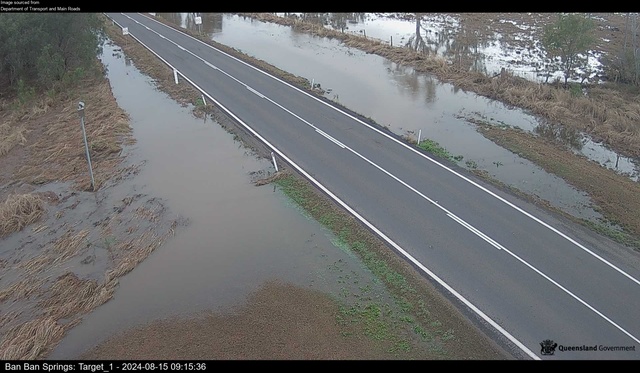
The Burnett Highway at Ban Ban Springs is no longer covered by water - but nearly half a dozen roads in the North Burnett remain impassable to drivers due to floodwaters or debris. (Supplied)

Over half a dozen roads in the North Burnett are still flooded out, with heavy rain in the region since Tuesday morning creating detours for drivers.

The North Burnett Regional Council Emergency Management Dashboard shows 7 flood-related road warnings, five of which are full road closures, as of Thursday morning, 15 August.

The Burnett Highway at Ban Ban Springs, a main way into the North Burnett which was impassable to motorists since Tuesday evening, has reopened – but travellers in the area are still urged to drive with caution.

Full closures include two sections of Paradise Dam Road at Coringa north of Biggenden, and a section of O’Bil Bil Road and Malmoe Road in Malmoe, a locality between Eidsvold and Mundubbera.

The Malmoe Road section is reportedly shut due to debris on the road washed up by floodwaters.

The Bureau of Meteorology has maintained its minor flood warning for the Burnett River, reporting some sections of the Burnett, Auburn and Boyne Rivers have already breached their banks.

The Burnett River at Mundubbera, which BoM were fearing might exceed its minor flood level of 7 metres on Wednesday evening, has plateaued at 5.52m as of 8:20am on Thursday.

The receding waters at Mundubbera have also allowed Jack Parr Bridge to reopen; the low-set crossing over the Burnett River was completely covered by floodwaters on Wednesday.

At Gayndah, the Burnett River also failed to reach its 5-metre minor flood level, staying steady at around 4.6 metres as of Thursday morning.

Three Moon Creek at Abercorn, which rose another metre since 10am on Wednesday to stand at 3.85m, is now reported to be falling once again.

Paradise Dam has begun discharging its excess water into the Burnett River system after reaching a capacity of 114.40 per cent at 8pm on Wednesday.

As of writing, the dam has lost 0.56 per cent or 955 million litres of water.

Rainfall across the North Burnett has nearly completely stopped as of Thursday morning, after up to 145 millimetres of rain were recorded in some places of the region earlier this week.

The road closures are as follows:

Malmoe: Malmoe Road; Road closed to all traffic, Use alternative route

Malmoe: O’Bil Bil Road; Road closed to all traffic, Use alternative route

Glenrae: Boondooma Road; All lanes affected, Proceed with caution

Degilbo: Seccombes Road; Road closed to all traffic, Use alternative route

Coringa: Paradise Dam Road; Road closed to all traffic, Use alternative route

Didcot: Gooroolba Biggenden Road; All lanes affected, Do not drive in flood waters

Ban Ban Springs: Burnett Highway; All lanes affected, Do not drive in flood waters

To stay up to date with the latest closures, visit the North Burnett Regional Council Emergency Management Dashboard on emergency.northburnett.qld.gov.au.

To read more about Paradise Dam, read our story on burnetttoday.com.au/south/2024/08/14/millions-of-litres-headed-downstream-as-paradise-dam-floods