Yet another severe storm hit the South and North Burnett regions overnight, causing roads to flood and plunging locals into darkness.
A supercell-level storm heading north-east impacted the Burnett around 5pm on Thursday, 23 January.
The Bureau of Meteorology’s Kingaroy observation station recorded wind gusts of up to 67km/h, as well as around 10mm of rain.
However, other parts of the region reported even worse conditions: floodwaters rose in Proston’s main street, the locality of Durong reported heavy winds, and fallen trees blocked roads at Wattle Grove, Inverlaw and Nanango.
In the North Burnett, the town of Mount Perry also reported storm damage, with a number of locals stating hailstones battered their houses.
POWER OUTAGES
Ergon Energy Network crews are out on Friday morning, 24 January, investigating the power outages across the South Burnett region.
An Ergon Energy Network spokesperson stated that during the 23 January storm their lightning strike count within a 100km radius of Nanango was more than 280,000.
“Our crews are seeing the effects of the storms during their fault-finding patrols,” an Ergon Energy Network spokesperson said.
“They’ll need to fix the damage before they can safely restore power to all affected customers.”
Ergon Energy reminds their South Burnett customers to be aware of potential fallen powerlines which could be hidden in tree branches and other debris.
“We really appreciate your patience in the heat and our local crews wanted to send a special thank you to our customers in the South Burnett, who have been so supportive despite bearing the brunt of storms in the last few weeks,” they said.
As of this morning, pockets of people across the Burnett are still without power, with Ergon reporting outages near the Bunya Mountains, Hivesville, Goomeri, Ban Ban Springs and Mount Perry.
RIVER LEVELS
The Bureau of Meteorology is reporting that river levels are still on the rise following last night’s storm.
The upper Boyne River system is experiencing flooding, with a floodwater peak approaching Boondooma Dam this morning.
The Bureau reported that minor flooding – levels above 2.5 metres – may occur at Dunollie on late Friday morning.
Other rising watercourses include Three Moon Creek at Abercorn, which is at 1.65m, as well as Barambah Creek at Joe Sippel Weir and Stonelands, standing at 0.24m and 2.97m respectively.
ANECDOTES
The severe storm hit Proston with a downpour, causing trees to fall and roads to flood.
Robyn White lives along Nelson Street, which flooded on Thursday night for the second time in a fortnight.
“I’ve lived here 23 years and have never had a storm like last night,” she said.
“The lightning and wind were scary.”
The water on Nelson Street rose up to about a foot deep in the storm, something that has become more frequent since a new drain was installed further up the street.
“In the past couple of years, this part of the road has become rapids,” Ms White said.
Meanwhile, over at Durong residents and their properties are feeling the strain of the deluge of repeated storms.
Durong resident Michelle Griffin and her neighbours have a lot to clean-up after the Thursday night storm.
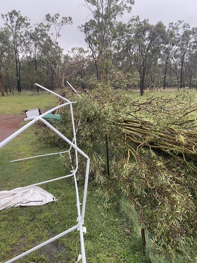
A 25 metre-high tree fell, narrowly missing her house and a canopy shelter was ripped apart in the strong winds. In the morning they found more trees fallen along their fenceline.
“We have had so much rain in the past couple of months that the ground can’t hold anymore water, so that [the] winds last night was the last straw for the poor trees,” Ms Griffin said.
Further rain is still possible throughout Friday and Saturday, the Bureau of Meteorology reported.
A list of closed roads as reported by the South Burnett Regional Council follows:
Wheatlands, Byee Road: Flooding, All lanes affected – as of 24/01/2025 6:08am
Cloyna, Gayndah Road: Hazard, No blockage, Proceed with caution – as of 23/01/2025 5:41pm
Barker Creek Flat, McNamara Road: Flooding – Road closed to all traffic – as of 24/01/2025 08:25am
Booie, Mondure Crossing Road: Flooding, All lanes affected – as of 24/01/2025 07:46am
Brooklands, Darley Estate Road: Flooding, Road closed to all traffic – as of 24/01/2025 07:45am
Durong, Shellytop Road: Flooding, Road closed to all traffic – as of 24/01/2025 07:36am
Haly Creek, Weeks Road: Flooding, Road closed to all traffic – as of 24/01/2025 07:36am
Chahpingah, Broad Creek Road: Flooding, Road closed to all traffic – as of 24/01/2025 07:35am
Mount McEuen, Mount McEuen Road: Flooding, Road closed to all traffic – as of 24/01/2025 07:34am
Wengenville, Maidenwell Glencliff Road: Flooding, Road closed to through traffic, Use alternative route – as of 24/01/2025 07:34am
Wengenville, Upper Barker Creek Road: Flooding, All lanes affected, Observe signage – as of 24/01/2025 07:33am
Inverlaw, Kingaroy Hoopers Road, Hoopers Road: Flooding, Road closed to through traffic – as of 24/01/2025 07:33am
Wengenville, Wengenville Glencliffe Road: Hazard, Road closed to all traffic – as of 24/01/2025 07:31am
Merlwood, Friebergs Road: Flooding, All lanes affected, Observe signage – as of 23/01/2025 12:51
Brigooda, Trentham Road: Hazard, Road closed to all traffic, Use alternative route – as of 23/01/2025 12:44am
Redgate, Clovely Lane: Flooding, Road closed to all traffic – as of 23/01/2025 12:44am