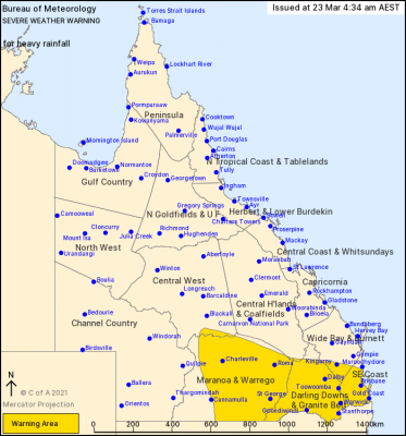
A rainbank is expected to bring heavy rainfall and the risk of flash flooding to southern and southeast Queensland today and tonight.
Locations which may be affected include Kingaroy, Brisbane, Ipswich, Gold Coast, Toowoomba, Warwick, Stanthorpe, Dalby, Goondiwindi, Roma, Charleville and St George.
A strong upper trough combined with a deep moist airflow is expected to bring widespread areas of heavy rainfall and thunderstorms across southern Queensland to the southeast coast on Tuesday and overnight into early Wednesday morning.
The heavy rainfall which may lead to flash flooding is likely over the Maranoa and Warrego area today with six hourly rainfall totals of 50-70mm likely, and locally heavier falls are possible with thunderstorms.
Meanwhile, in the Darling Downs, Granite Belt and southeast coast districts can expect heavy rainfall which may lead to flash flooding. The situation is likely to pose a serious risk to areas recently affected by heavy rainfall, including the risk of landslips in steep terrain, in these areas the situation may become life-threatening.
Queensland Fire and Emergency Services advises that people should:
* Never drive, walk or ride through flood waters. If it’s flooded, forget it.
* Keep clear of creeks and storm drains.
* For emergency assistance contact the SES on 132 500.