FLASH FLOODING: North Burnett, Gympie regions on alert, South leans forward
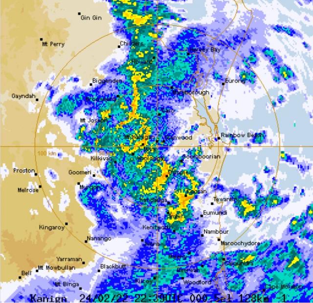
The Bureau of Meteorology has recorded intense rainfall on Friday morning, 25 February.

An emergency alert has been issued for the North Burnett and Gympie regions this morning, as reports surface of flooded roads and vehicles swept away.

EMERGENCY ALERT ISSUED

A flood warning for the North Burnett region has been issued by the Bureau of Meteorology. Flash flooding is occurring and roads and bridges may by impacted.

The council is urging residents to sty off the roads if possible and stay tuned to the Bureau for warning.

For more information, visit: emergency.northburnett.qld.gov.au/

An emergency alert has also been issued for residents in Goomeri, Woolooga and western townships in the Gympie Local Government Area, with flood flashing occuring in these areas.

The Queensland Fire and Emergency Services reported the Goomeri township is now closed and inaccessible.

Stay up-to-date on the latest in the Gympie region here: disaster.gympie.qld.gov.au/

For flood assistance, contact the SES on 132 500. In a life-threatening emergency, dial triple zero (000)

SOUTH BURNETT LEANS FORWARD

The South Burnett Local Disaster Group has moved its status to “Lean Forward” this morning.

The LDMG has been provided a weather update and the region could expect to see a further 50mm – 100mm of rainfall today and possibly overnight. There is also a possibility that some areas may receive even higher rainfall particularly on the eastern parts of region and in areas that are in the elevated catchment.

The LDMG advises that road closures of major roads along with Council roads are commencing and Council’s dashboard is now operational. People should consider their need to travel and it is likely that further closures of major roads will occur this afternoon, particularly between northern and southern routes such as the Burnett and Bunya Highways.

The links to Council’s dashboard can be found at dashboard.southburnett.qld.gov.au/. The Dashboard is updated periodically as information is advised and confirmed.

Remember to contact 000 in an emergency and do not drive in flood water, “If its flooded, forget it!”.

PAIR CAUGHT IN FLOODING

Two motorists are lucky to be alive after their car was reportedly swept away in floodwaters at Dallarnil earlier this morning.

A Queensland Ambulance Service report alerted the public to an ongoing incident just before 7am Friday 25 February, wherein two patients were being assessed by paramedics on Gospel Hall Road, Dallarnil.

The pair were reportedly swept away in their car at 3.49am, with Queensland Ambulance Service and Queensland Fire and Emergency Services crews attending the scene shortly thereafter.

A QAS spokesperson confirmed the patients were uninjured and did not require transport to hospital.

Queensland Fire and Emergency Services advises that people should:

* Move your car under cover or away from trees.

* Secure loose outdoor items.

* Seek shelter, preferably indoors and never under trees.

* Beware of fallen trees and powerlines.

* Never drive, walk or ride through flood waters. If it’s flooded, forget it.

* Keep clear of creeks and storm drains.

* For emergency assistance contact the SES on 132 500.

LIST OF ROADS CLOSED

Roads closed due to flooding as of 9am today:

Coringa: Paradise Dam Road , from 25/02/2022 06:36

Biggenden: Maryborough Biggenden Road – Maryborough West, from 25/02/2022 07:00

Degilbo: Gooroolba Biggenden Road, from 25/02/2022 06:51

Biggenden: Isis Highway, from 25/02/2022 07:01

Coringa: Grills Road / River Road, from 25/02/2022 6:38 am

Woowoonga: Isis Highway, from 25/02/2022 8:42 am

Goomeri: Burnett Highway, from 25/02/2022 07:25

Booubyjan: Booubyjan Hall Road, from 25/02/2022 08:30

Kilkivan: Kilkivan Tansey Road, from 25/02/2022 08:56

Redgate: Clovely Lane from 25/02/2022 9am

SEVERE WEATHER WARNING

The Bureau of Meteorology has issued severe weather warnings including heavy rainfall and damaging winds for parts of southeast Queensland.

A strong upper low will move slowly eastward across southeast Queensland Friday and through Saturday.

A deepening and slow-moving surface trough that extends from Seventeen Seventy down to a developing low pressure system near Biggenden and over the eastern Darling Downs will continue to produce areas of heavy rain with embedded thunderstorms.

Heavy rainfall which may lead to flash flooding is forecast to continue over parts of Southeast Queensland today and potentially through Saturday morning. Six-hourly rainfall totals between 80 and 120 mm are likely, reaching up to 180 mm over areas east of Gympie to Jimboomba.

Locally intense rainfall leading to dangerous and life-threatening flash flooding is possible with thunderstorms during this period, particularly over areas north of Brisbane. Six-hourly rainfall totals in excess of 300 mm are possible. A separate Severe Thunderstorm Warning will be issued if very dangerous thunderstorms with intense rainfall are detected.

Locations which may be affected include Toowoomba, Brisbane, Maroochydore, Gympie, Bundaberg, Kingaroy, Caboolture, Ipswich, Cherbourg, Oakey, Jimboomba and Mount Tamborine.

WIDESPREAD POWER OUTAGES, NORTH BURNETT

Over 3,000 residents of the North Burnett and the neighbouring Fraser Coast regions are out of power following the sudden heavy rainfall this morning, with energy provider Ergon rushing crews out to 40 different locations to repair the damages.

Between 2am and 3:21am this morning, 1,154 residents in the Biggenden area and subsequently 1,977 residents in the central North Burnett lost power due to what Ergon reports as unplanned outages as a result of damage to the network.

Ergon crews are currently on site in the Biggenden area to find the damage responsible for the outage, while as of writing crews are still en route to the central North Burnett to carry out repairs.

Ergon lists the estimated time of completion for repairs as “unknown”.

Locations affected:

Abercorn, Binjour, Boynewood, Brovinia, Ceratodus, Coonambula, Cynthia, Derra, Eidsvold, Gayndah, Glenrae, Grosvenor, Gurgeena, Hawkwood, Hollywell, Malmoe, Mundowran, Mundubbera, O’bil Bil, Philpott, Riverleigh, Wondai, Wuruma Dam, Aramara, Biggenden, Boompa, Brooweena, Coalstoun Lakes, Coringa, Dallarnil, Degilbo, Doongul, Eliott, Gigoomgan, Lakeside, North Aramara, Teebar, Woocoo, Woolooga, Woowoonga.

Update: The outage in the Eidsvold area has been fixed as of noon, with power restored to most residents in the area. The outage at Biggenden persists.

RAINFALL TOTALS

The Bureau of Meteorology recorded 6-hourly rainfall to 4.30am:

Old Range Road (N of Biggenden) recorded 423 mm (389 mm in 3 hours to 4am).

Fig Tree (N of Biggenden) recorded 315 mm.

Paradise Dam recorded 289 mm

Fred Haigh Dam recorded 241 mm

Kandanga recorded 158 mm.

DAM LEVEL TOTALS

Paradise Dam is at 108.12%.

Fred Haigh Dam is at at 50.49%.

Boondooma Dam is at 97.67%.

Bjelke-Petersen Dam is at 102.26%.

Cania Dam is at 27.69%.

Wuruma Dam is at 69.56%.