Road flooding warnings after woman rescued
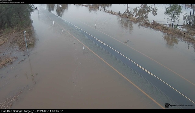
The Burnett Highway at Ban Ban Springs is closed to traffic due to heavy flooding. A woman was rescued from the area on Tuesday night after her car became trapped in the rising waters. (Supplied)

Drivers in the North Burnett are urged to plan their journeys ahead of time this morning, as heavy rain and flooding have forced a number of road closures across the region.

The North Burnett Regional Council Emergency Management Dashboard shows 14 flood-related road closures as of Wednesday morning, 14 August.

The majority of closures are concentrated around the Biggenden area, however a number of closures are also reported around Mundubbera and Gayndah.

The closures include one of the main ways into or out of the region, with the Burnett Highway at Ban Ban Springs closed to all traffic.

Locals and travellers alike are urged to take the warnings seriously, as just last night a woman in her 60’s attempted to traverse the floodwaters at Ban Ban Springs and became trapped.

The Queensland Ambulance Service reports first responders were able to rescue the woman, whose vehicle had stopped at the intersection of the Burnett and Isis Highways at Ban Ban Springs just before 7pm on 13 August.

She was transported to Biggenden Hospital and was reportedly uninjured.

The Bureau of Meteorology have issued minor flood warnings for the Burnett River up to and downstream of Mundubbera and Paradise Dam.

BoM have reported the Burnett River at Mundubbera may reach the minor flood level of seven metres on Wednesday morning and may rise beyond this level going forward; however as of 8:20am on Wednesday the river levels were reported at 5.52 metres and falling.

At Gayndah, the river may reach its five-metre minor flood level on Wednesday.

The Burnett River at ‘Marriages’ has reached its minor flood level as of 9:43am, standing at 4.48 metres.

Other waterways across the North and South Burnett are also experiencing rising levels.

Three Moon Creek at Abercorn stands at 2.83 metres as of 10:20am on Wednesday, having risen over 80 centimetres since 1:25am; the creek’s levels are still expected to rise as of writing.

The Auburn River at Flagstone Bridge is expected to rise from its current level of around 1.4 metres.

Cadarga Creek at Brovinia has exceeded the five-metre mark and minor flood level as of 10am on Wednesday.

Degilbo Creek at Coringa, which caused some of the flood-related road closures between Tuesday and Wednesday, had exceeded its moderate flood level and neared the seven-metre mark; however as of 10:25am on Wednesday its levels were reported to be dropping.

The Burnett River catchment has experienced up to 145 millimetres of rainfall since 9am on Tuesday, 13 August, with the highest total recorded at Mount Gayndah.

Rainfall has largely eased up across the region according to the Bureau, with most monitoring stations recording no rain as of 10am; however, the Bureau maintains its predictions of rising river levels and urges motorists and residents of the North Burnett to remain cautious.

The road closures are as follows:

Malmoe: Malmoe Road; Road closed to all traffic, Use alternative route

Glenrae: Boondooma Road; Road closed to all traffic, Use alternative route

Malmoe: Obil Bil Road; Road closed to all traffic, Use alternative route

Coonambula: A Creek Road; All lanes affected, Proceed with caution

Lakeside: Lower Lakeside Road; Road closed to through traffic, Use alternative route

Degilbo: Seccombes Road; Road closed to all traffic, Use alternative route

Coringa: Paradise Dam Road; Road closed to all traffic, Use alternative route

Woowoonga: Mount Woowoonga Road; Road closed to through traffic, Use alternative route

Degilbo: Emu Creek Road; Road closed to all traffic, Use alternative route

Bon Accord: Wetheron Road; Hazard, Road closed to all traffic, Use alternative route

Coonambula: Coonambula Road; Road closed to all traffic, Do not drive in flood waters

Kalpowar / Molangul (Bundaberg): Kalpowar Road between Kalpowar and Molangul; All lanes affected, Do not drive in flood waters

Didcot: Gooroolba Biggenden Road; All lanes affected, Do not drive in flood waters

Ban Ban Springs: Burnett Highway; All lanes affected, Do not drive in flood waters

To stay up to date with the latest closures, visit the North Burnett Regional Council Emergency Management Dashboard on emergency.northburnett.qld.gov.au.