Weather forecasters have put the Wide Bay-Burnett on alert, warning of potentially severe thunderstorms in the South and North Burnett and Gympie areas for Wednesday and Thursday.
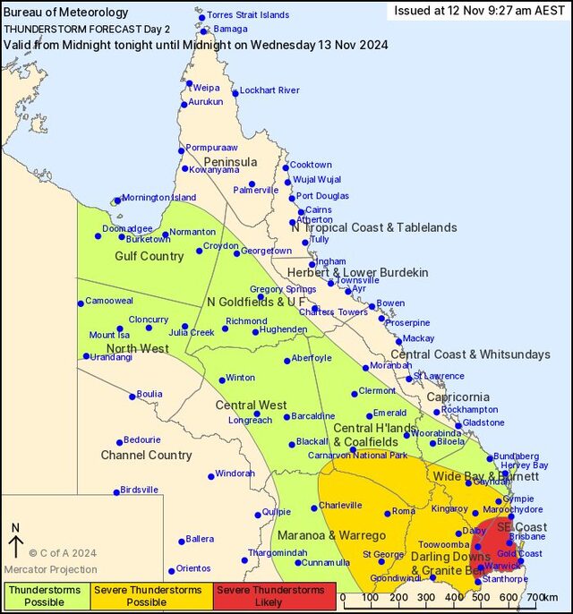
The Bureau of Meteorology have published their thunderstorm forecast for Wednesday, 13 November, predicting a high chance of showers as well as potentially severe storms featuring hail, lightning and damaging winds in the Burnett regions in the afternoon and evening.
The Bureau have not issued a definite thunderstorm warning for the Burnett at time of writing, but large sections of the Burnett regions were declared as ‘possible’ or ‘likely’ targets for thunderstorms.
According to the organisation’s definition, when a severe thunderstorm is ‘possible’ it means a 10 to 30 per cent chance of hail bigger than two centimetres, damaging wind gusts over 90 km/h, and heavy rainfall that may lead to flash flooding.
When a severe storm is ‘likely’, the possibility rises to over 30 per cent.
For Wednesday, ‘possible’ areas include the majority of the South Burnett and southern parts of the North Burnett, while the southernmost parts of the South Burnett were declared as ‘likely’ areas for severe storms.
On Thursday, the Bureau’s predictions see the risk of severe weather continue, though high-end storms are less likely to occur.
WHAT CAUSES A STORM?
The storm risk comes after a significant heatwave in the Burnett the week prior, which saw temperatures soar into the 40’s.
Christie Johnson, a meteorologist for the Bureau, explained that severe heat often precedes thunderstorms.
“We’ve had a lot of very hot air being pushed down over the south-east of Queensland,” Ms Johnson explained.
“To make a storm, we need an unstable atmosphere – which we have at the moment thanks to that earlier heat.
“Part of the reason we’re now seeing these cooler temperatures is that we’ve got a bit of a wind change, which is pushing up southerly winds.
“There is a trough lying from the Gulf country down toward South East Queensland,” she said, explaining that a ‘trough’ is an area where two wind directions converge and push into one another causing air to rise upward.
“That trough which causes these changing conditions can itself actually be a trigger for thunderstorm activity,” Ms Johnson explained.
However, a range of other factors are also driving this week’s increased likelihood for storms.
“There’s also currently an upper-level system that’s going to provide more support for that storm – it helps the storms potentially become bigger,” the Bureau’s meteorologist explained.
“That is why today and tomorrow might be the peak of the thunderstorm activity, after which it will likely ease off a bit – although there is still a risk over the northern Wide Bay-Burnett area into Friday.
“Storms also need moisture, which we currently have feeding down from the tropics.
“It’s a few things today that are converging to give us this potentially severe storm outbreak,” Ms Johnson said.
HOW TO ACT?
The Bureau of Meteorology issues thunderstorm warnings with a very short lead time, Ms Johnson explained, owing to the ever-developing nature of weather systems.
To avoid confusion and undue panic, the Bureau will only report on a storm when it is certain it will occur.
As such, residents of the Burnett looking to stay informed about any incoming storm warnings are asked to download the BoM app and enable push notifications.
The Bureau’s advice to people facing a potential storm is to move their cars into an undercover area to prevent hail damage, as well as to either bring inside or tie down any large objects on their properties to avoid the items being blown away by heavy winds.
Ms Johnson urged motorists to drive to conditions and to never drive into or through floodwater.
To see the Bureau’s latest severe weather warnings, visit bom.gov.au/qld/warnings/
View the region’s latest radar images on bom.gov.au/products/IDR083.loop.shtml#skip