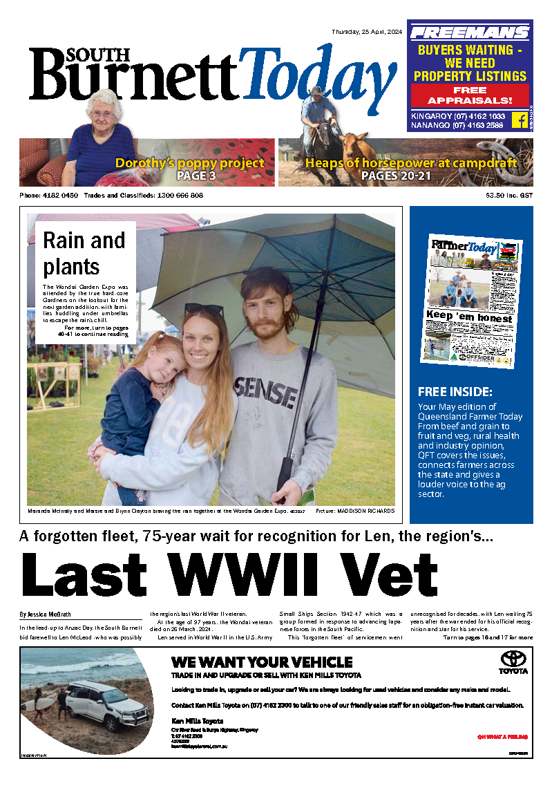
Barkers and Cooyar Creeks are two of many swollen waterways in the Burnett region due to recent heavy rain.
On Wednesday afternoon, 11 December there were a total of 44 roads in the South Burnett Regional area affected by flooding and by Thursday, 12 December a sunny day saw the flooded roads list reduced to 34.
According to Sunwater, as of 3pm on Thursday, 12 December the Bjelke-Peteresen Dam is sitting at 96.81 per cent, Boondooma Dam at 103.75 per cent, Wuruma Dam at 77.71 percent and Paradise Dam is sitting at 98.25 percent.
Meteorologist Jonathan How from the Bureau of Meteorolog reported that showers, rain and thunderstorms were expected mostly north of Bundaberg on Thursday, 12 December.
“It will also be dry across southeast Queensland, but we do have a number of flood warnings and watches current, especially around Kingaroy,” he said.
The Bureau’s flood warning issued on Wednesday 11 December at 10.45am for the Burnett River catchment was still in place by Thursday afternoon.
The Bureau reported rainfall totals of up to 105mm across the Burnett River catchment over a few days, which has caused the river levels to rise with minor to major flooding occurring in parts of the Barker Creek and Stuart River. No significant rainfall had been recorded since 9am on Wednesday.
However, The Bureau reported that showers and thunderstorms were still possible over the next few days, but meteorologists were not expecting significant rainfall.
In the Stuart and Boyne River areas, minor flooding occurred along the Stuart River upstream of Boondooma Dam, with small river rises at downstream locations.
Meanwhile in the Barker and Barambah Creek catchment, The Bureau reported minor to major flooding.
Barkers Creek is usually a small winding creek which begins at the base of the Bunya Mountains National Park, and runs north past Nanango and then feeds into the Bjelke Petersen Dam.
Embreys Bridge over Barkers Creek which is the main thoroughfare between Kingaroy and Nanango at this stage remains open, whereas further down the creek, Kingaroy Barkers Creek Road at Booie remains closed, completely inundated with flood waters.
Meanwhile, just outside of Yarraman the Cooyar Creek goes through the Ted Pukallus Weir before splitting in two, also forming Bear Creek.
Pillars of an old railway bridge sit iconically next to the D’Aguilar Highway at the Harland Park rest stop alongside Cooyar Creek.
This spot forms part of the Brisbane Valley Rail Trail, where usually cyclists can cross the small stream of Cooyar Creek and admire the old bridge pillars -however at the moment flood waters have made the trail impassable.
Motorists, pedestrians and cyclists are reminded to be cautious and not to cross a flooded section of a road -no matter how shallow it looks.
Remember if it is flooded, forget it.
For flood emergency assistance contact the SES on 132 500. For life threatening emergencies, call Triple Zero (000) immediately.
Refer to the South Burnett Disaster Management Dashboard for updates on road closures here: dashboard.southburnett.qld.gov.au/ and QLD Traffic’s maps: qldtraffic.qld.gov.au/index.html
Read more about the closed roads in the Burnett, the flooding in the Burnett and local rescue missions here:
Roads closed in the South Burnett due to flood waters as of 4pm, Thursday 12 December include:
Booie: Mondure Crossing Rd (road closed to all traffic)
Brooklands: Kingaroy Cooyar Road and Barker Creek Bridge (road closed to all traffic)
Brooklands: Darley Crossing Rd (road closed to all traffic)
Brooklands: Darley EstateRd (road closed to all traffic)
Brooklands: Kumbia Rd (road closed to through traffic)
Chahpingah: Kingaroy Burrandowan Road (road closed to all traffic)
Chahpingah: Hodges Dip Rd (All lanes affected)
Crawford/ Memerambi: Bunya Highway (all lanes affected)
Chelmsford: Flats Rd (all lanes affected)
Glan Devon: Booie Rd (road closed to through traffic)
Glan Devon: Paige Road (road closed to all traffic)
Haly Creek: Haly Creek Rd (road closed to all traffic)
Inverlaw: Hoopers Rd (road closed to all traffic)
Murgon: Boat Moutain Rd (all lanes affected)
Okeden: Proston Boondooma Road (road closed to all traffic)
Redgate: Clovely Lane (road closed to all traffic)
Sandy Ridges: Kingaroy Barkers Creek Road (road closed to all traffic)
Sandy Ridges: Glenmore Rd (road closed to all traffic)
Sandy Ridges: Robin and Lee Rd (road closed to all traffic)
Silverleaf: Campbells Rd (All lanes affected)
Stonelands: Webbers Bridge Rd (road closed to all traffic)
Wilkesdale: Memerambi Gordonbrook Road (road closed to all traffic)
Wondai: Bunya Highway (no blockage)
Wondai: Byee Road (all lanes affected)
Wyalla: Burnett Highway (road closed to all traffic)
Wyalla: Memerambi Barkers Creek Rd (all lanes affected)
Wheatlands: Wondai Proston Road (no blockage)
Wengenville: Upper Barker Cree Rd (all lanes affected)
Wengenville: Tim Shea Creek Rd (all lanes affected)
Wengenville: Wengenville Glencliffe Rd (Road closed to all traffic)