Burnett residents are being urged to be prepared for potential severe thunderstorms, and even tornadoes, this weekend.
Bureau of Meteorology reported the next few days had the potential for severe thunderstorms across Queensland and New South Wales.
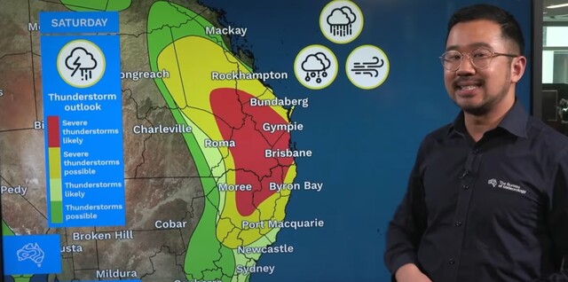
“This will peak on Saturday with the potential for very dangerous conditions,” meteorologist Jonathan How said.
On Friday, 31 October, thunderstorms are possible for a vast area of eastern Australia.
At 2.55pm the Bureau issued a severe thunderstorm warning for the Wide Bay and Burnett, with large, possibly giant hailstones, damaging, locally destructive winds and heavy rainfall possible.
Over the next few hours a severe thunderstorm is likely in an area stretching from Boonah to north of Monto including, the South Burnett and North Burnett. Earlier on Friday, at 1.50pm golf ball sized hail (4cm) was reported near Gatton.
Mr How explained that on Friday a number of surface troughs are dragging a lot of moisture and creating “very unstable conditions” across the eastern seaboard, with strong winds in the upper atmosphere creating the ‘perfect storm’ of conditions for scattered severe thunderstorms.
Rain showers are expected to persist overnight.
However on Saturday 1 November, the liklihood of a severe thunderstorm across the Burnett, and wider spread from the mid north coast of NSW to the Central Highlands of Queensland increases.
The trough will move closer towards the coast on Saturday, which will combine with the wind change moving up the coast and really peeking during Saturday afternoon and evening.
Mr How urged residents in the severe storm forecast area to be prepared for potential large hail and destructive winds which could cause damage to tress and property, dangerous travel conditions and power outages.
“The areas in yellow again may see heavy rainfall, large hail and damaging winds,” Mr How said.
“We have a very large area where severe thunderstorms are likely in red.”
Mr How noted this included inland communities like Kingaroy, Dalby and Toowoomba, as well as Brisbane and parts of the Gold Coast and Sunshine Coast.
“In the red area we may see life-threatening flash flooding with intense rainfall, giant hail and destructive winds,” he said.
“With some of these more intense supercell thunderstorms moving through, we can’t rule out the possibility of tornadoes.”
On Sunday, the conditions are expected to ease up, with still a potential for showers.