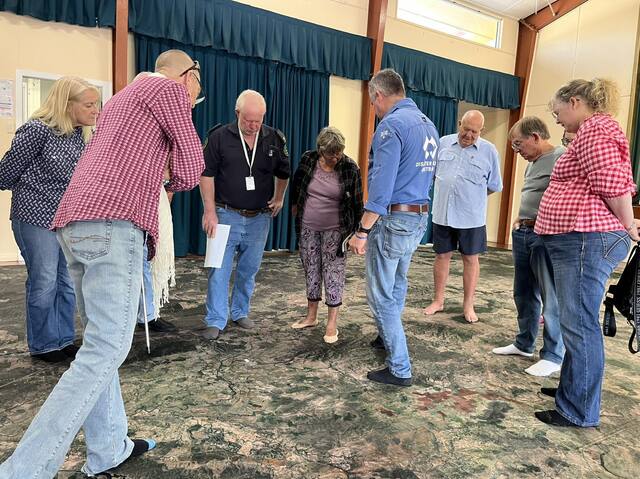
Burnett residents in Biggenden and Kingaroy came together last weekend for the first round of Red Earth Community Foundation’s ‘Big Map’ events.
Ahead of Get Ready Queensland Week, which is this year observed from 8 to 13 October, attendees learned how their communities are impacted by floods, fires and other disasters with the help of military-spec mapping software.
A massive floor map of the Burnett region is at the heart of these sessions, giving locals a chance to ‘walk the map’ and mark locations of homes and critical infrastrucutre which are prone to flooding and fire.
Red Earth’s Kimberley Kunde said both communities brought a “wealth of knowledge” to their respective sessions.
“Hearing the stories from residents who’ve experienced previous disasters firsthand is invaluable. This local insight helps us build a stronger foundation for resilience and more effective warning systems,” she said.
“Newcomers and long-term residents alike found the exercise eye-opening, as they discussed how natural features like river catchments and terrain impact disaster risk,” Red Earth’s project manager Amanda Wenck said.
Disaster Relief Australia’s Adam Moss, who facilitated the sessions, explained that an understanding of the surrounding environment is crucial for disaster preparedness.
“The Big Map sessions provide a unique, hands-on way for people to see and understand the lay of the land and where risks might come from,” he said.
Georgie Somerset, the chairperson of Red Earth Community Foundation, added that a community member’s local knowledge is a valuable commodity – not just for keeping themselves safe but also when it comes to keeping others informed.
“If shared, [a person’s] insights and experiences can help improve the [whole] region’s disaster preparedness through information being made available to Council, emergency management agencies and other key stakeholders,” Ms Somerset said.
“Locals can inform [these agencies] about what is needed to establish effective flood warning systems, mitigation efforts and responses that will be required during an event,” she added.
Along with Disaster Relief Australia, North Burnett Regional Council and multinational engineering company AECOM will be at the upcoming Mundubbera and Monto Big Map events to hear from locals who have any information that will help inform current flood mitigation projects.
“The marks on your shed displaying the water height or the markers that you use down the creek are significant, and that data will help the North Burnett become more resilient to flooding events,” Ms Somerset said.
“It is great that Council and Red Earth can utilise the Big Map events to collaborate for the benefit of community.”
The events are also supported by the ‘Disaster Resilient: Future Ready Burnett Inland’ program, a partnership between the Foundation for Rural and Regional Renewal and Red Earth.
The dates for the upcoming Big Map events are:
Friday, 11 October – 9am to 3:30pm, Murgon PCYC
Saturday, 12 October – 9am to 3:30pm Mundubbera Community Hall
Sunday, 13 October – 9am to 3:30pm, Monto Community Hall
Register online forms.office.com/r/xNVnbmxd33 for catering purposes or by emailing resilience@disasrreliefaus.org.
If you are unable to attend a session in the town closest to you, you are welcome to attend any of the sessions across the Burnett Inland.