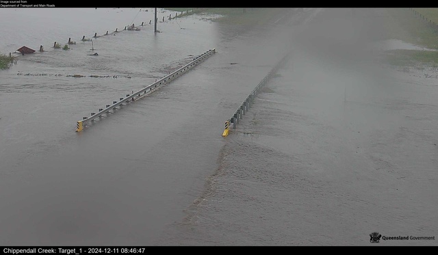
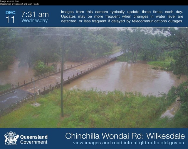
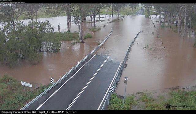
Heavy rainfall continues to batter the Burnett, locking down roads across the region as rivers and creeks swell up.
A total of 41 roads across the South Burnett including the nearby towns of Yarraman and Goomeri are currently blocked off due to either flooding or fallen vegetation caused by this week’s rain.
The Bureau of Meteorology reports its measuring station at Kingaroy has received 57 millimetres of rain between 9am on 10 December and approximately 5am on 11 December, with more recent data unavailable at time of writing.
The Bureau’s Brooklands weather station has meanwhile recorded a staggering 144mm of rain in the past 24 hours.
Some river levels throughout the region are also still rising: the Stuart River at Proston stands at 3.11 metres, and at Weens Bridge it has spilled onto the road, standing at 6.24 metres as of 12pm – 0.14m above the bridge level.
Barambah Creek is also rising: at West Barambah stands at 5.11 metres as of 11:20am, at Litzows it stands at 2.45 metres, and at Silverleaf Weir its height is 1.24 metres.
The Burnett River at Eidsvold is at 1.21 metres as of 12pm.
As of 10:45am, the Bureau has issued a flood warning for the Burnett River.
The organisation reported ‘isolated moderate to major flooding’ along Barker Creek, caused by over 100mm of rainfall across the Burnett River catchment since Tuesday.
Barker Creek at Embreys Bridge is at 7.05 metres – just 0.35 metres below the bridge level – and at Glenmore it has broken the three-metre mark, being at 3.27 metres and thus under a metre below the highway.
As rainwater raises the creek and river levels, the Burnett’s dams thave also begun to swell: Boondooma Dam at Proston has increased by nearly 7,000 megalitres since 9 December and currently stands at 86.85 per cent capacity.
Bjelke-Petersen Dam is similarly surging, with owners Sunwater reporting its capacity at 87.16 per cent – up three per cent or nearly 4 billion litres of water in the past 12 hours.
Rain and wind have caused power outages at Benarkin North, South Nanango and Wattle Camp. As of writing, approximately 30 people are without power, down from over 130 earlier in the day, and Ergon crews are working to repair damages.
The renewed rainfalls have again nearly claimed motorist lives: two people had to be rescued from Parker Road in Ellesmere, when their car got caught in floodwaters around 8:12pm on 10 December.
They were taken to Kingaroy Hospital as a precaution, but were not injured.
The rescue came after another person was pulled from floodwaters at Brooklands on 9 December.
Emergency services have reminded drivers to avoid flooded areas, and to never venture directly into floodwaters.
A list of all flood-related road closures across the South Burnett, Yarraman and Goomeri, as of 2pm on 11 December, follows. Please note several closure notices have not been updated for some time by council or the Department of Transport.
• Ficks Crossing, Kangaroo Yard Road – Flooding, Road closed to through traffic – as of 11/12/2024 12:12pm
• Taabinga, Aerodrome Road – Flooding, All lanes affected, Observe signage – as of 11/12/2024 12:06pm
• Kingaroy, Hodges Road – Flooding, Road closed to through traffic – as of 11/12/2024 13:39pm
• Kingaroy, First Avenue – Flooding, Road closed to all traffic – as of 11/12/2024 12:01pm
• Kingaroy, First Avenue – Flooding, Road closed to through traffic – as of 11/12/2024 11:43am
• Kingaroy, River Road – Flooding, Road closed to through traffic – as of 11/12/2024 11:39am
• Kingaroy, Somerset Street – Flooding, All lanes affected, Observe signage – as of 11/12/2024 08:37am
• Murgon, Boat Mountain Road – Flooding, All lanes affected, Proceed with caution – as of 11/12/2024 11:54am
• Sandy Ridges, Glenmore Road – Flooding, Road closed to all traffic – as of 11/12/2024 11:03am
• Sandy Ridges, Kingaroy Barkers Creek Road – Flooding, Road closed to all traffic – as of 11/12/2024 11:43am
• Inverlaw, Kingaroy Burrandowan Road- Flooding, Road closed to all traffic – as of 11/12/2024 11:38am
• Chahpingah, Kingaroy Burrandowan Road- Flooding, Road closed to all traffic – as of 11/12/2024 11:33am
• Wheatlands, Wondai Proston Road – Flooding, No blockage – as of 11/12/2024 11:20am
• Redgate, Clovely Lane – Flooding, Road closed to all traffic – as of 11/12/2024 10:19am
• Haly Creek, Haly Creek Road – Flooding, Road closed to all traffic – as of 11/12/2024 11:41am
• Haly Creek, Stuart Valley Drive – Flooding, Road closed to through traffic – as of 11/12/2024 10:09am
• Wyalla, Manumbar Road – Flooding, Road closed to through traffic – as of 11/12/2024 12:03pm
• Wyalla, Burnett Highway – Flooding, All lanes affected – as of 11/12/2024 11:08am
• Durong, Chinchilla Wondai Road – Flooding, Road closed to all traffic – as of 11/12/2024 7:50 am
• Goodger, Kingaroy Cooyar Road – Flooding, Road closed to all traffic – as of 11/12/20244:47 am
• Wilkesdale, Memerambi Gordonbrook Road – Flooding, Road closed to all traffic – as of 11/12/2024 3:09am
• Bunya Mountains, Bunya Mountains Road, In the vicinity of Maidenwell Bunya Mountain Road intersection – Hazard (Fallen vegetation), All lanes affected, Proceed with caution – as of 10/12/2024 3:52pm
• Yarraman, Emmert Street – Flooding, Do not drive in flood waters – as of 10/12/2024 6:15 am
• Wondai, Bunya Highway at Dingo Creek – Flooding, No blockage – as of 11/12/2024 11:15am
• Wondai, Greenview Road – Flooding, All lanes affected, Observe signage – as of 11/12/2024 08:41am
• Glan Devon, Walsh Road – Flooding, All lanes affected, Observe signage – as of 11/12/2024 08:23am
• Wattle Camp, Memerambi Barkers Creek Road – Flooding, All lanes affected, Proceed with caution – as of 11/12/2024 08:19am
• Booie, Mondure Crossing Road – Flooding, Road closed to all traffic – as of 11/12/2024 07:54am
• Booie, Booie Road – Flooding, Road closed to all traffic – as of 11/12/2024 09:27am
• Sandy Ridges, Robin and Lee Road – Flooding, Road closed to all traffic – as of 11/12/2024 07:53am
• Tarong, Nanango Tarong Road – Hazard, No blockage, Proceed with caution – as of 11/12/2024 11:11am
• Tarong, Tarong Railway Road – Flooding, Road closed to through traffic – as of 11/12/2024 07:52am
• Tarong, Kingaroy Cooyar Road – Flooding, Road closed to all traffic – as of 11/12/2024 4:45 am
• Barker Creek Flat, McCauley Broome Road – Flooding, Road closed to through traffic – as of 11/12/2024 07:51am
• Barker Creek Flat, McNamara Road – Flooding, Road closed to through traffic – as of 11/12/2024 07:49am
• Brooklands, Nanango Brooklands Road – Flooding, Road closed to through traffic – as of 11/12/2024 08:00am
• Brooklands, Kunioon Road – Flooding, Road closed to all traffic – as of 11/12/2024 07:51am
• Brooklands, Nanango Brooklands Road – Flooding, Road closed to through traffic – as of 11/12/2024 07:50am
• Brooklands, Darley Crossing Road – Flooding, Road closed to all traffic – as of 11/12/2024 07:49am
• Brooklands, Darley Estate Road – Flooding, Road closed to all traffic – as of 11/12/2024 07:47am
• Glan Devon, Paige Road – Flooding, Road closed to all traffic – as of 11/12/2024 07:48am
• Nanango, Brown Street – Flooding, Road closed to through traffic – as of 11/12/2024 07:43am


