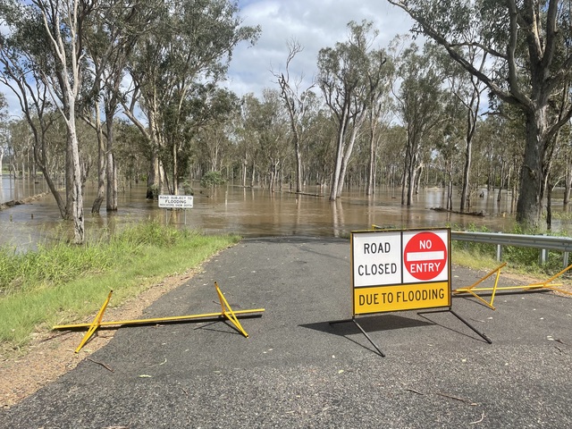
Heavy rainfall after the ground has already been saturated and swelling rivers thanks to more than a week of almost constant rain have seen several roads across the Burnett region flooded.
Police and North and South Burnett councils have reminded motorists not to drive through flooded roads, following another round of storms on the night of 18 December.
Queensland Police Service Deputy Commissioner and State Disaster Coordinator Shane Chelepy said there is no reason for people to be driving through floodwaters.
“It does not matter how big your car is, or how equipped it is to handle four-wheel-drive conditions, it will not save you if you can’t see what is underneath the water and the road gives out from underneath you,” Deputy Commissioner Chelepy said.
“Have a backup plan for when conditions change, so you can get home safe to your loved ones.”
“If it means you have to take a longer route home, or wait out the wet weather, then I’d rather you be late home to your family, than never make it.”
Emergency crews across the state have responded to multiple rescues recently, where motorists have driven through floodwaters and gotten swept away.
A swiftwater rescue was almost needed last night in the South Burnett.
A Queensland Fire Department spokesperson stated that at Merlwood near Murgon a large amount of water came down the side of a hill and impacted two cars.
Queensland Fire Department crews arrived, but the water was only at wheel height and no response was required.
STAND UP: Council on alert
Last night, 18 December, the South Burnett Local Disaster Management Group moved its disaster warning level from Alert to Stand Up.
This morning the group met to assess the damage of last night’s storms, with Mayor Kathy Duff saying road repair costs have already climbed well past a quarter of a million dollars.
SOUTH BURNETT
There are currently 67 roads closed roads due to flooding in the South Burnett region.
Barker Creek Flat:
McCauley Broome Rd (road closed to all traffic)
McNamara Rd (road closed to through traffic)
Booie:
Malar Rd (road closed to all traffic)
Booie Rd (all lanes affected)
Byee:
Lancasters Rd (all lanes affected)
Brooklands:
Nanango Brooklands Rd (road closed to all traffic)
Kumbia Rd (road closed to all traffic)
Kunioon Rd (road closed to through traffic)
Darley Crossing Rd (road closed to all traffic)
Darley Estate Rd (road closed to all traffic)
Chahpingah:
Hodges Dip Rd (all lanes affected)
Cloyna / Silverleaf:
Silverleaf Rd (road closed to all traffic)
Chelmsford:
Flats Rd (all lanes affected – observe signage)
Cushnie:
G Andersons Rd (all lanes affected)
Durong:
Shellytop Rd (road closed to through traffic)
Ficks Crossing:
Kangaroo Yard Rd (road closed to all traffic)
Glan Devon:
Phipps St W (all lanes affected – observe signage)
Booie Rd (road closed to all traffic)
Walsh Rd (all lanes affected)
Paige Rd (road closed to all traffic)
Haly Creek:
Stuart Valley Dr (all lanes affected – observe signage)
Flagstone Creek Rd (road closed to all traffic)
Kingaroy:
Kingaroy Barkers Creek Road (road closed to all traffic)
River Rd (road closed to all traffic)
Pound St (all lanes affected – observe signage)
Clark and Swendson Rd (road closed to through traffic)
Hoopers Rd, Inverlaw (road closed to through traffic)
Weens Rd (road closed to all traffic)
Maidenwell:
Maidenwell Bunya Mountains Road (road closed to all traffic)
Marshlands:
Hivesville Windera Rd (road closed to through traffic)
Merlwood:
Friebergs Rd (all lanes affected – observe signage)
Moffatdale:
Tipperary Rd (road closed to all traffic)
Murgon:
Bunya Highway (proceed with caution – lanes reduced)
Boat Mountain Rd (all lanes affected – observe signage)
Nanango:
Brown St (road closed to all traffic)
Redgate:
Kilcoy Murgon Road (all lanes affected)
Steinhardts Rd (road closed to all traffic)
Clovely Lane (road closed to all traffic)
Runnymede:
Runnymede Rd (all lanes affected)
Sandy Ridges:
Kingaroy Barkers Creek Road (road closed to all traffic)
Kings Bridge Rd (all lanes affected)
Robin and Lee Rd (road closed to all traffic)
Silverleaf:
Campbells Rd (road closed to all traffic)
Stonelanes:
Webbers Bridge Rd (road closed to all traffic)
Taabinga:
Bellbird Road (all lanes affected)
Toomeys Rd (road closed to all traffic)
Geritz Rd (road closed to all traffic)
Aerodrome Rd (road closed to all traffic)
Wattlecamp:
Wattle Camp Rd (road closed to all traffic)
Wyalla:
Burnett Highway (all lanes affected)
Wengenville:
Maidenwell Glencliff Rd (road closed to through traffic – use alternative route)
Upper Barker Creek Rd (all lanes affected – observe signage)
Tim Shea Creek Rd (road closed to through traffic)
NORTH BURNETT
A dozen roads in the North Burnett region are affected by floods, according to the North Burnett Regional Council’s emergency dashboard records.
Ban Ban Springs:
Burnett Highway (all lanes affected)
Bon Accord:
Wetheron Rd (hazard – road closed to all traffic, use alternative route)
Biggenden:
Lords Rd (all lanes affected – proceed with caution)
Boynewood:
Boondooma Rd (all lanes affected – proceed with caution)
Coringa:
Grills Rd (road closed to all traffic – use alternative route)
Degilbo:
Degilbo Mines Rd (all lanes affected – proceed with caution)
Seccombes Rd (road closed to all traffic – use alternative route)
Gooroolba Biggenden Rd (road closed to all traffic – use alternative route)
Glenrae:
Boondooma Rd (road closed to all traffic – use alternative route)
Lakeside:
Swindle Creek Rd (all lanes affected – proceed with caution)
Malmoe:
Obil Bil Rd (road closed to all traffic – use alternative route)
Mundubbera:
Riverleigh School Bus Rd (all lanes affected – proceed with caution)
Woowoonga:
Lower Lakeside Rd (all lanes affected – do not drive in flood waters)
Remember: if the road is flooded, forget it!


