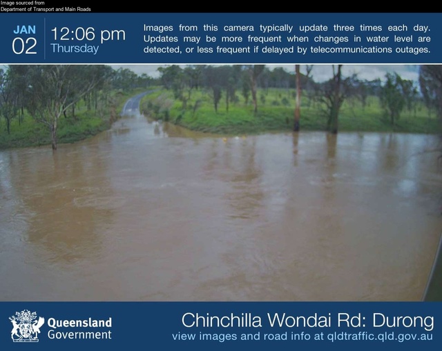
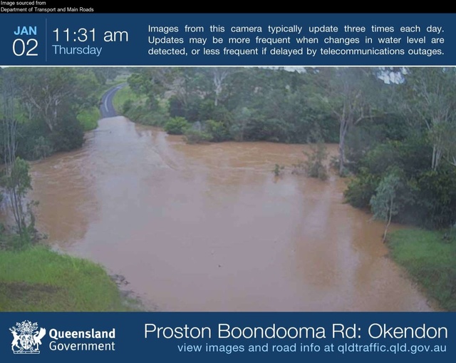
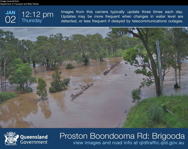
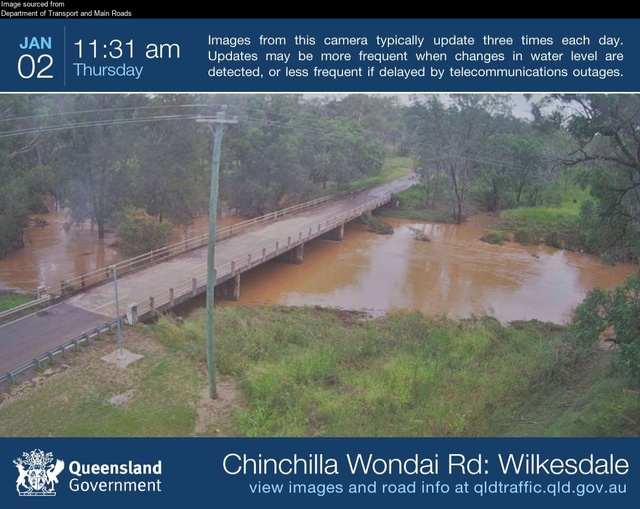
On New Year’s Day Burnett residents experienced another heavy downpour and flash flooding, following on from several major rain and flood events throughout December.
South Burnett Regional Council’s Disaster Management team issued an update at 10am on Thursday 2 January, to report flash flooding had eased and waters had started to recede.
Council advised residents to return to their homes and businesses to check for damage.
Meanwhile, the North Burnett Regional Council reported that moderate to heavy rainfall has resulted in some minor flooding across the North Burnett region.
The North Burnett’s council reminded residents to check on their neighbours and make sure they have supplies.
Minor flooding is still occurring along several Burnett waterways, however for now the flash flooding threat is reduced.
FLOOD WARNINGS
The Bureau of Meteorology issued a flood warning for the Stuart and Auburn Rivers, and Barker and Barambah Creeks. The Bureau has also issued a minor flood warning for the Boyne and lower Burnett Rivers.
The warnings, current as of 9:30am on 2 January, stated that moderate to heavy rainfall on Monday and Wednesday evenings has resulted in river and creek level rises across the Burnett River catchment.
South Burnett:
Minor flooding has been reported along the Boyne River at Boondooma Dam.
Over at Proston, moderate flooding at the ‘major flood level mark’ was observed at the Stuart River early Thursday morning, as well as along the Boyne River at Carters and Cooranga.
Moderate flooding is easing along Barker Creek, while minor flooding has been recorded along Barambah Creek at the Silverleaf Weir.
North Burnett:
Minor flooding has been reported along the Boyne River, standing at around 4.55 metres at Dunollie, with meteorologists predicting the level to reach a peak of around six metres over the night of Thursday and into Friday.
The Bureau recorded elevated water levels at the Auburn River and its tributaries, with minor flooding easing at Brovinia after peaking early Thursday morning.
The water has flowed down into the Burnett River, with minor flooding predicted to peak around the seven-metre mark at Mundubbera late Thursday, and near the 5.5-metre mark at Gayndah on early Friday morning.
The influx of floodwater will continue to Biggenden’s Paradise Dam, which is currently at a capacity of 105.28 per cent and was spilling excess water as of 31 December.
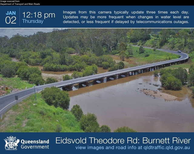
Meanwhile, the Burnett River at Eidsvold Bridge is expected to remain below the minor flood level during Thursday.
The Bureau is reporting that showers and thunderstorms are possible until Saturday, however the forecast rainfall totals are not expected to significantly affect river levels.
MORE SIGNIFICANT RAINFALL
Some parts of the Burnett marked the new year with more significant rainfall.
In the 24-hour period from 9am on 1 January to 9am on 2 January the following rainfall totals were recorded by the Bureau of Meteorology:
Mt Walsh: 21mm
Gayndah: 4.8mm
Mundubbera: 4mm
Hawkwood: 48mm
Dykehead: 85mm
Brovinia: 79mm
Cooranga (Boyne River): 17mm
Dunollie: 18mm
Boondooma: 29mm
Proston: 31mm
Brigooda: 51mm
Ficks Crossing: 8mm
Kingaroy: 21mm
Brooklands: 31mm
ROADS DAMAGED, CLOSED
The South Burnett’s council reported significant damage to the region’s road network, with mud and debris covering roads and surrounding areas.
The top priority of council crews will be to re-open the roads as soon as possible, according to a South Burnett Regional Council spokesperson.
“Drive slowly, obey all road signs and never drive through floodwaters. If the road is flooded or damaged, go another way,” they stated.
Bridges, however, will take longer as they can not be reopened until a certified bridge inspector can check each of the structures.
“Please be mindful, this can take time. We are seeking the community’s patience and understanding while we navigate and inspect our road network,” council’s spokesperson said.
North Burnett road closures:
As of writing, the North Burnett Regional Council disaster dashboard reports nine road closures across the region due to flooding or hazards.
The following North Burnett roads are closed:
Bon Accord: Wetheron Road (road closed to all traffic – hazard)
Dallarnil: Grills Road (all lanes blocked – flooding)
Degilbo: Seccombes Road (all lanes affected – flooding)
Derri Derra: Hawkwood Road (all lanes affected – flooding)
Eidsvold: Ross Cross Road (all lanes blocked – flooding)
Grosvenor: Grosvenor A Creek Road (road closed to through traffic – flooding)
Lakeside: Maryborough Biggenden Road (all lanes affected – flooding)
Malmoe: Malmoe Road and Obil Bil Road (roads closed to all traffic – flooding)
Toondahra: Boondooma Road (road closed to all traffic – flooding)
South Burnett road closures:
The South Burnett council’s disaster dashboard reported 50 roads closed at time of writing due to flooding and other hazards.
Barker Creek Flat:
D’Aguilar Highway (lanes affected)
McNamara Road (road closed to through traffic)
Booie:
Mondure Crossing Road (road closed to all traffic)
Booie Road (all lanes affected)
Brigooda:
Proston Boondooma Road (road closed to all traffic)
Trentham Road (road closed to all traffic – hazard)
Brooklands:
Darley Crossing Road (road closed to all traffic)
Darley Estate Road (road closed to all traffic)
Kunioon Road (road closed to all traffic)
Chahpingah:
Broad Creek Road (road closed to all traffic)
Durong:
Kingaroy Burrandowan Road (road closed to all traffic)
Chinchilla Wondai Road (road closed to all traffic)
Shellytop Road (road closed to through traffic)
Cushnie:
Cushnie Road (all lanes affected)
Glan Devon:
Phipps Street West (all lanes affected)
Paige Road (road closed to all traffic)
Walsh Road (all lanes affected)
Greenview:
Tingoora Chelmsford Road (all lanes affected)
Gordonbrook:
Memerambi Gordonbrook Road (road closed to all traffic)
Kingaroy:
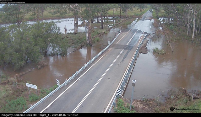
Kingaroy Barkers Creek Road (all lanes affected)
Hodges Road (road closed to through traffic)
Tuite Street (road closed to all traffic)
Harris Road (all lanes affected)
Hoopers Road, Inverlaw/Kingaroy (road closed to through traffic)
Kumbia:
Hays Road (road closed to through traffic – hazard)
Marshlands:
Hivesville Windera Road (road closed to all traffic)
Merlwood:
Friebers Road (all lanes affected)
Mount McEuen:
Mount McEuen Road (road closed to all traffic)
Nanango:
Brown Street (road closed to all traffic)
Okeden:
Proston Boondooma Road (road closed to all traffic)
Redgate:
Clovely Lane (road closed to all traffic)
Runnymede:
Runnymede Road (all lanes affected)
Sandy Ridges:
Kingaroy Barkers Creek Road (road closed to all traffic)
Robin and Lee Road (road closed to all traffic)
Glenmore Road (all lanes affected)
Silverleaf:
Campbells Road (all lanes affected)
Stonelands:
Webbers Bridge Road (road closed to all traffic)
Taabinga:
Aerodrome Road (road closed to all traffic)
Tingoora:
Chinchilla Wondai Road (all lanes affected)
Bunya Highway (all lanes affected)
Wattlecamp:
Memerambi Barkers Creek Road (all lanes affected)
Wengenville:
Maidenwell Glencliff Road (road closed to through traffic)
Upper Barker Creek Road (all lanes affected)
Wengenville Glencliffe Road (road closed to all traffic – hazard)
Wheatlands:
Wondai Proston Road (road closed to all traffic)
Mondure Wheatlands Road (all lanes affected)
Wondai:
Bunya Highway (all lanes affected)
Byee Road (road closed to all traffic)
WET DECEMBER
The New Year’s Day rain came after an unexpected heavy downpour had already caused flash flooding in Kingaroy on 30 December.
To find out more about the recent floods, visit:

